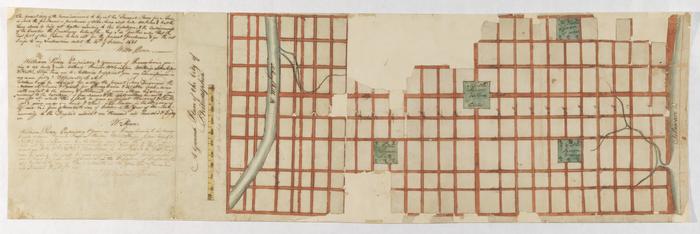
A Ground Plan of the City of Philadelphia
Permanent ID:
10653
Call number:
Of 610* 1681 (?)
Date:
circa 1683
Image Description:
Portion of Thomas Holme's map of Philadelphia showing a ground plan of the city and proposed location of public squares. In 1682, William Penn appointed Holme surveyor-general of Pennsylvania and charged him with the task of laying out the "greene country towne" that Penn envisioned along the Delaware River. The site that Penn acquired for the city of Philadelphia stretched two miles east to west across a tract of land situated between the Delaware and Schuylkill Rivers; all told, the rectangular grid of land comprised twelve thousand acres. Holme imposed an orderly grid plan on the site, with streets organized around a large square in the center of the town and four smaller squares, one in each quadrant. The grid also included two main streets, Broad and High (present-day Market), which were kept wide in hopes of preventing the kind of fire that destroyed London in 1666.
Address:
Philadelphia
Format:
Map