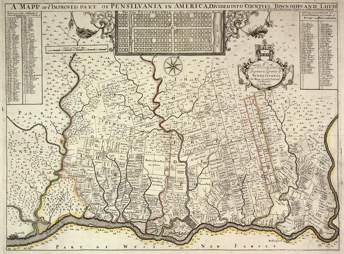
A Mapp of ye Improved Part of Pensilvania in America [sic]
Permanent ID:
1124Call number:
Of 500* 1690HbDate:
circa 1690Image Description:
Thomas Holme's A Mapp of Ye Improved Part of Pensilvania. In 1682, William Penn appointed Holme surveyor-general of Pennsylvania and charged him with the task of laying out the "greene country towne" that Penn envisioned along the Delaware River. The site that Penn acquired for the city of Philadelphia stretched two miles east to west across a tract of land situated between the Delaware and Schuylkill Rivers; all told, the rectangular grid of land comprised twelve thousand acres. Holme imposed an orderly grid plan on the site, with streets organized around a large square in the center of the town and four smaller squares, one in each quadrant. The grid also included two main streets, Broad and High (present-day Market), which were kept wide in hopes of preventing the kind of fire that destroyed London in 1666. Holme's first map of the city, A Portraiture of the City of Philadelphia, was completed in 1683.In 1684, William Penn requested that Holme make a second, more detailed map showing the progress of settlement and land ownership in the colony. Completed in 1687, A Mapp of Ye Improved Part of Pensilvania detailed the area from New Castle to about ten miles above the falls of the Delaware and as far west as the Brandywine Creek. Holme's map also included the name of each landowner within the outlines of their property. Upon its completion, William Penn had A Mapp of Ye Improved Part of Pensilvania printed and engraved in London, hoping it would entice more settlers to the colony.