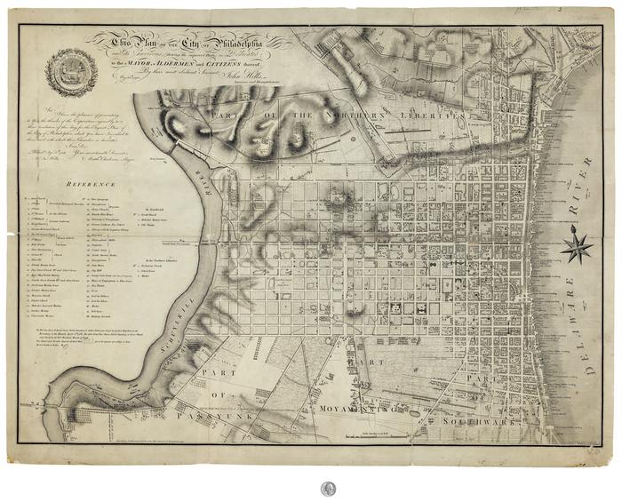
John Hill Plan of Philadelphia, 1797
Permanent ID:
230Call number:
Of 610 1796HiDates:
May 30 1796September 6 1796
1797
Image Description:
Full Title: This Pan of the City of Philadelphia and Its Evirons, (showing the improved Parts,) is Dedicated to the Mayor, Aldermen and Citizens thereof, by their most immediate Servant,John Hills- Surveyor and Draughtsman.
Map of Philadelphia including part of adjacent townships Moyamensing, Passyunk, Southwark, and Northern Liberties. Shows details of various creeks, ponds, hills, canals and other topagraphical features.
Inscription:
Sir, I have the pleasure of presenting to you the thanks of the Corporation, agreeably to their resolution of this day for the Elegant Plan of the City of Philadelphia, which you have inscribed to them, and with which their Chamber is decorated.I am, Sir, Your most humble servent,
Matthw Clarkson, Mayor
Phila, Sept 5th, 1796
Mr Jn HIlls
Address:
PhiladelphiaFormat:
MapDimensions:
Width: 98 cm, Height: 73.8 cm (case)Collection:
Historical Society of Pennsylvania map collectionRelated People or Organizations:
John Cooke (engraver)John Hills (creator)
Library of Congress Subjects:
Hill, John, 1770-1850 [info:lc/authorities/names/nr88000324]
Maps [info:lc/authorities/subjects/sh85080858]
Maps [info:lc/authorities/subjects/sh85080858]