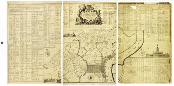
John Reed Map of the City and Liberties of Philadelphia, 1774
Permanent ID:
2795Call number:
Of 610* (1774)Date:
1774Image Description:
This map is comprised of three separate panels of varying condition (the dimensions apply to the individual panels). The first image is an artificial composite of the three that has also been color corrected in photoshop.Format:
Engravings; MapDimensions:
Width: 51.7 cm, Height: 78.4 cmCollection:
Chew Family papersRelated People or Organizations:
Reed, John (cartographer)Smither, James (engraver)
Library of Congress Subjects:
Maps [info:lc/authorities/subjects/sh85080858]
United States--Historical geography--Maps [info:lc/authorities/subjects/sh85140128]
Center City District (Philadelphia, Pa.) [info:lc/authorities/names/n89110897]
Northern Liberties (Philadelphia, Pa.) [info:lc/authorities/names/n88172944]
Reed, John [info:lc/authorities/names/n79149427]
United States--Historical geography--Maps [info:lc/authorities/subjects/sh85140128]
Center City District (Philadelphia, Pa.) [info:lc/authorities/names/n89110897]
Northern Liberties (Philadelphia, Pa.) [info:lc/authorities/names/n88172944]
Reed, John [info:lc/authorities/names/n79149427]